


DRONE SURVEY AND
MAPPING SPECIALISTS.
Nationwide, across the United Kingdom

Authorised by the UK Civil Aviation Authority
We hold a full 'operational authorisation' (3375) to operate UAV's upto 20kg 24 hours per day.

£10m Public Liability Insurance
EC785/2004 compliant. We plan our jobs meticulously ensuring the safe operation of our drones and personnel.


FalconUAV speaks VOLUMES
Using the latest technology, we have worked alongside some of the largest aggregate companies in the UK to deliver volumetric surveys with survey grade accuracy. We have become one of the market leaders in measuring stockpiles and aggregate bays without the need to climb stockpiles with the risks significantly reduced.
Our clients love what we do, because we do it safely. Whilst on site we do not need to halt production or close the factory whilst the survey is taking place other than to place our GCP's (Ground control points) and collect (5-10 minutes unless no vehicles moving on site). As long as we are able to bring everyone 'under our control' whilst the UAV is airborne we are happy to keep your plant running.
Some of our biggest clients include the following;
With over 10 years experience in volumetric surveying, we come highly recommended by our current client base but our services are not just limited to survey work as we also cover 2D mapping, 3D modelling, aerial photography, aerial videography, inspection work and much more.
Please feel free to get in touch today for a free, no hassle quotation on your drone needs.


FalconUAV SERVICES


Whilst specialising in Volumetric Surveys, we also offer a multitude of other drone solutions including but not limited to;
-
Construction progression photography
-
Boundary surveys
-
Site maps & plans
-
Photogrammetry
-
Aerial photography
-
Aerial videography
-
Magnetic near hit / accident maps
-
3D modelling
-
Pointclouds (.las, .xyz etc)
-
Data Processing services
-
Golf Course mapping
-
Wedding photography
and more...

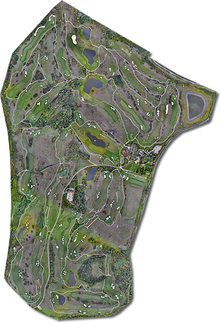
FalconUAV FEATURED PRODUCT
FalconUAV have undertaken several golf golf course mapping projects for clients who have then gone onto turn our models into a fully functional, playable virtual reality game for PC, Xbox and Playstation.
On average spending 2-3 days at each course, flying around 200-400ft to capture exceptional detail which is transformed into a pointcloud and delivered direct to the client which is then edited and turned into a CGI development.
London Golf Club, Kent. Flown by FalconUAV March 2020.

FalconUAV safer then SAFE
Drones have had some bad press recently due to negligent operators. We pride ourselves on being safe.
With the current laws and regulations set by the Civil Aviation Authority on the usage of drones, our teams, managed by a former NQE Instructor plan each job meticulously and work with air traffic controllers, airfields, heliports to deliver a safe operation and gain data for our clients.
Every job has its own risk assessment & site assessment upon arrival before our equipment is setup.
We seek full written permission for every job which is close to an airport, heliport or anywhere that may have aerial activity taking place. We don't just stop there, once permission has been obtained, things can change so we also make contact when our equipment has been setup and ready to fly and gain final permission before starting our tasks.
We pride ourselves on being safe, there is so much room for error in aviation and we triple check everything, twice!
Full PPE is worn whilst on any site as part of our standard operating procedures.
Some of the airports we have worked with recently and successfully gained permissions;


People who love what we do..


